

Details
Grade: 1
Distance: 3.9 Miles / 6.3km
Elevation Gain: 180 ft / 55 metres
Start/Finish: Hope Church. Grid Reference: SK 1725 8350. Nearest Post Code: S33 6RD (250 metres away)
Hazards: Road crossings, including 2 busy ‘A’ roads, although in 30mph zones. Railway crossing. Wooden stiles, may be slippery when wet. Cattle may be in some fields.
Introduction
 1")
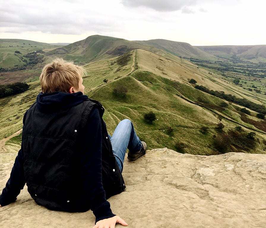
The Hope Panorama run provides a great little tour of the spectacular valley in which Hope village and Castleton nestle. As a Grade 1 run it is relatively flat, with only short/gentle hills to contend with, but the setting is fantastic. As you traverse the valley, you’ll have great views in every direction. The hills of Mam Tor, Lose Hill and Win Hill tower above you, as does Peveril Castle perched high above Castleton. And the dramatic valleys of Winnats Pass and Cave Dale, which are visible at times, give a real appreciation of the landscape.
The Route
Start
From Hope Church, cross the main road with CARE and head north along Edale Road (at side of Old Hall Hotel).
Distance to next instruction (m): 350
0.4km from Start
At junction with Bowden Lane, turn left off Edale Road onto footpath between two walls.
Distance to next instruction (m): 100
0.5km from Start
Go through wicket gate and turn right on footpath, signposted Lose Hill. Continue on path through a series of wicket gates.
Distance to next instruction (m): 270
0.7km from Start
Follow path as it turns right and immediately left to cross a footbridge over the railway (limit of 20 people on footbridge). Continue through two more wicket gates.
Distance to next instruction (m): 90
0.8km from Start
Take footpath that runs along the side of ‘The Meadows’ house.
Distance to next instruction (m): 70
0.9km from Start
At far end of buildings take footpath that continues straight on. Ignore left turn to Castleton Road.
Distance to next instruction (m): 230
1.1km from Start
Bear right through wicket gate (with painted yellow arrow on post) to follow footpath across the field.
Distance to next instruction (m): 170
1.3km from Start
Bear left to follow footpath which skirts around edge of field to gate in left hand corner. Do NOT take footpath signposted Mam Tor via Losehill.
Distance to next instruction (m): 80
1.4km from Start
Go through gate, over wooden decking and continue on footpath in same direction. Hope cement works visible on your left.
Distance to next instruction (m): 410
1.8km from Start
Follow footpath signposted Castleton over wooden bridge and across field on far side.
Distance to next instruction (m): 290
2.1km from Start
Go through kissing gate and continue on footpath alongside stables.
Distance to next instruction (m): 50
2.1km from Start
On reach Spring House Farm Holiday Cottages, turn left along driveway.
Distance to next instruction (m): 50
2.2km from Start
Turn right on unpaved tracked, signposted Castleton.
Distance to next instruction (m): 240
2.4km from Start
At track junction turn left and immediately right to continue on track in same direction.
Distance to next instruction (m): 200
2.6km from Start
At entrance to Riding House Farm go straight on though wicket gate and follow gravel footpath toward Castleton.
Distance to next instruction (m): 190
2.8km from Start
Bear slighly left through wicket gate (at side of main gate) and continue on track.
Distance to next instruction (m): 370
3.2km from Start
At end of track turn left onto tarmac lane.
Distance to next instruction (m): 520
3.7km from Start
Turn left at footpath sign on to Mill Lane (unpaved track) and follow through premises.
Distance to next instruction (m): 200
3.9km from Start
On reaching main road in Castleton (opposite village hall), cross with CARE and turn left towards Hope.
Distance to next instruction (m): 180
4.1km from Start
50 metres before bend in road, turn right onto track (footpath sign for Hope).
Distance to next instruction (m): 310
4.4km from Start
As track peters out continue straight on footpath in same direction.
Distance to next instruction (m): 60
4.4km from Start
Go through wicket gate and continue on footpath along left hand side of field (Hope cement works chimney directly in front).
Distance to next instruction (m): 240
4.7km from Start
Follow footpath as it bears left at bend in stream and across field towards stile in distance.
Distance to next instruction (m): 230
4.9km from Start
Go over stile and continue across fields through a series of stiles and pedestrian gates.
Distance to next instruction (m): 230
5.1km from Start
Bear slightly left to go around left hand side of raised mound of earth with trees on, and continue towards far left hand corner of field.
Distance to next instruction (m): 240
5.4km from Start
Go though wicket gate, cross railway line with CARE at level crossing and continue on footpath in same direction.
Distance to next instruction (m): 260
5.6km from Start
Continue on footpath in same direction through a series of gates.
Distance to next instruction (m): 370
6.0km from Start
Go over stile and turn left down lane towards Hope.
Distance to next instruction (m): 300
6.3km from Start
Turn left on main road to return to starting point at Hope Church.
Distance to next instruction (m): 50
 2")
)