

Stunning Castleton Circular Walk : Details
Distance: 5.5 miles
Time: 2-3 hours
Terrain: Hill paths and trails, country lanes
Accessibility: Moderate, with inclines and uneven terrain, gates, no stiles
Start and End Point: Grid Ref SK 14958 83022; Postcode S33 8WN; /// modifies.working.extend
Map: Ordnance Survey Explorer OL1
Stunning Castleton Circular Walk : Introduction
This stunning Castleton circular walk takes in the most classic views of this beautiful part of the Peak District, starting and ending in the pretty village of Castleton. On the way it climbs through the hidden gorge of Cave Dale, offering a wonderful perspective of Peveril Castle. From there it treks up on to Mam Tor and along the iconic Great Ridge, from where there are magnificent views of the Hope Valley and Edale Valley, before descending back into Castleton.
This is a walk of just over 5.5 miles. For the most part it uses clearly-marked trails and hill paths, with some country lanes. Be aware that the opening section through Cave Dale is quite rocky and follows the bed of a stream so is often wet underfoot, as is a short section on the way back down from Hollins Cross. Allow 2-3 hours to complete this walk at a moderate pace, allowing for rest stops to take in the views.
Castleton has a wide selection of pubs, cafes, restaurants and shops. We recommend The Peak Hotel for a great range of pub food and drinks. The walk starts and ends at the Visitor Information Centre, which also has a café and shop. There is a large public car park here (parking fees applicable).
Note: This route is provided in good faith and is correct at the time of publication. Please be aware that routes may be diverted over time as paths and access are altered, particularly in farming areas. Our directions should not be used instead of a map. You should always take a map with you to cross-reference the route.
Stunning Castleton Circular Walk : Directions
1. The walk starts from the car park at the Visitor Information Centre on Buxton Road in Castleton (postcode S33 8WN). From the car park walk to the main road and turn left, heading towards The Bull’s Head public house.
 1")
2. Once you reach The Bull’s Head pub, turn right and take the road immediately opposite, Castle Street, signposted to Peveril Castle. You will walk past two further pubs on Castle Street, The Castle and The George.
3. Follow the road as it bears left past the triangle of village green and the old market cross. Keeping the market cross on your left, follow the road up towards Pindale Road. Look out for a Public Bridleway sign to Cave Dale that leads off to the right between houses, to the immediate right of Dale Cottage, and follow the bridleway.
4. As you emerge into the beautiful gorge of Cave Dale, turn right and follow the path up through the limestone cliffs. You will see the ruins of Peveril Castle high up on your right.
 2")
5. Continue on the obvious path up through Cave Dale. Be aware that this path is uneven in places and often wet underfoot, so do take care. Keep straight on following the bridleway, ignoring other paths off. The path goes through several hand gates and sometimes tracks to the left of a stone wall.
 3")
6. As the path eventually levels off over open moorland, go through another hand gate in a stone wall towards an obvious sign post. Follow the marked Public Bridleway as it bears diagonally left over the brow of a hill.
7. At the corner of the field, you’ll come to two wide gates between stone walls. Immediately after the second gate, at a crossroads of paths, turn right through a metal gate to follow a grit lane between stone walls.
8. Keep following this lane as it turns right, ignoring the Public Bridleway that continues straight on through a further metal gate. The grit lane continues between a fence to the left and a stone wall to the right, with a farm visible on the right ahead and Mam Tor in the distance.
 4")
9. Continue on the grit lane past the farm and through a further gate, still keeping the stone wall to your right. You will eventually reach a metal gate that leads you to a road. Cross over the road with care and follow the Public Footpath through a gate and across a field almost immediately opposite, keeping to the right of a stone wall at first. Continue straight on as the wall bears left, following the well-marked path.
10. The path soon reaches another road. Again, cross with care and go straight on through a gate, following the Public Footpath sign opposite. The well-marked path now climbs steadily upwards towards the gap between Mam Tor to the right and Rushup Edge to the left.
11. Pass through another gate and up a series of steps, keeping right at the top and through a further gate on to Mam Tor. Follow the well-laid stone path upwards towards the trig point.
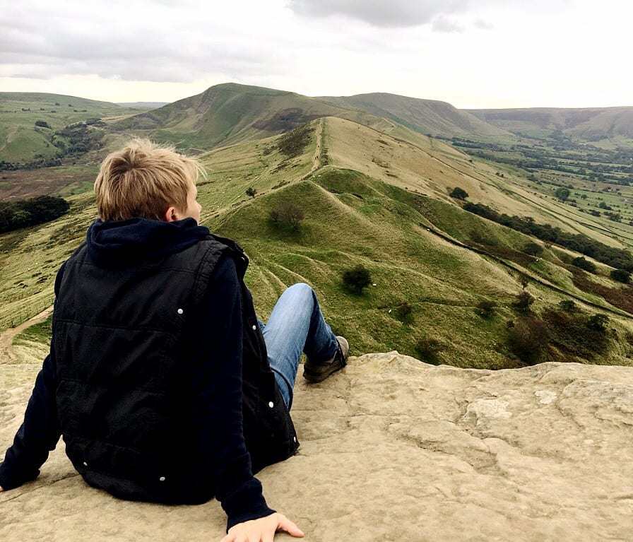
 5")
12. At 517m high, Mam Tor is one of the highest peaks in this part of the Peak District and the view from the trig point is well worth pausing to enjoy for a while. Facing in your direction of travel is the defined ‘backbone’ of the Great Ridge, with the Hope Valley laid out to your right and the Edale Valley to your left.
 6")
13. Continue on the stone path with the trig point on your left, and walk along the Great Ridge. On reaching a crossroads of paths, look out for a squat, round, stone waymarker known as Hollins Cross. At this point turn right through a gate. You will be immediately faced with a fork of paths; take the left hand fork to head down the hill.
 7")
14. Continue following this lovely path through bracken with views of Castleton ahead of you. Go straight on where a path joins from the right.
15. On reaching an obvious junction of paths turn right through a gate, following the Public Bridleway sign to Hollowford Road. The terrain here is uneven so take care, and the route follows a small stream for some distance so may be wet underfoot.
 8")
16. Continue straight on through a further gate, looking out for an interesting information board about this part of the landscape, the Liggate.
17. Follow the path straight on, signposted Hollowford Road to Castleton, and keep following this route as it widens out and becomes a quiet road. Follow the road as it curves between stone walls, ignoring footpaths off. The road soon reaches houses and leads back into the village of Castleton.
 9")
18. When you reach a T-junction in Castleton village, cross over the road to the footpath and turn right, passing the village primary school on your left. Follow the road as it bears right along the main road of Castleton, to soon reach your starting point at the Visitor Information Centre on your right.
Love this walk? Here are a few more you might enjoy…
For a longer walk from the station, try Edale to Mam Tor (7.5 miles), or explore quieter Hope Valley trails on Hope Village to Hope Cross Walk (6.7 miles). Plan a car‑free day with our Hope Valley Train Station Walks collection. If you’ve worked up a thirst, browse Peak District Pub Walks. Still looking? Explore all our Peak District walks.
)