



Derwent Edge Walk (9 Miles)
A grand ridge walk from Derwent Dam, climbing steeply to Back Tor then striding along Derwent Edge past iconic gritstone tors to Whinstone Lee Tor. Return along the peaceful shores of Ladybower Reservoir. Big skies, weird rocks, proper Peak District.
⚠️ Please note: This route has been created and shared by an Outdoor Active community member. It has not been checked or verified by Let’s Go Peak District. Please read the full walk description carefully, check weather and ground conditions before setting out, and look to community reviews and comments on Outdoor Active for up-to-date feedback. Always follow the Countryside Code.
View Full Route on Outdoor Active ↗Ladybower Reservoir & Derwent Edge: A Landscape Shaped by Water and Stone
The walk from Fairholmes Visitors Centre up to Derwent Edge and back along Ladybower Reservoir takes you through two very different but equally compelling Peak District landscapes, one carved by nature over millions of years, the other deliberately flooded by human hands less than a century ago.
The Lost Villages of Ladybower
When you stroll the return leg along Derwent Lane, with Ladybower’s waters lapping gently to your right, it’s worth remembering what lies beneath. Ladybower Reservoir was completed in 1945, the last and largest of the three reservoirs in the Upper Derwent Valley. Its construction submerged the villages of Derwent and Ashopton entirely, displacing farming communities that had worked this land for centuries.
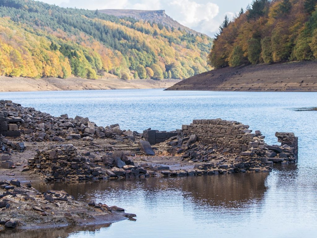
In dry summers, when water levels drop, the ghostly remains of Derwent Village sometimes reappear — stone gateposts, the foundations of Derwent Hall, and the old packhorse bridge that once carried farmers and traders across the River Derwent. It’s an eerie sight and a reminder that this seemingly natural landscape is, in fact, a carefully engineered water supply for the cities of Sheffield, Derby, Nottingham, and Leicester.
The Derwent Dam itself, completed in 1916, played a crucial role in the Second World War. The dam wall became the practice ground for 617 Squadron, the legendary Dambusters, as they perfected the low-level flying techniques needed for Operation Chastise, the bouncing bomb raids on Germany’s Ruhr Valley dams in 1943. A small museum at the visitors centre tells their story, and memorial flypasts still occasionally roar through the valley.
Derwent Edge: A Gritstone Skyline
If Ladybower tells a story of human engineering, Derwent Edge speaks of far older forces. This high ridge, topping out above 500 metres, is part of the Dark Peak’s Millstone Grit escarpment — a vast shelf of coarse sandstone laid down in a massive river delta some 320 million years ago, when this corner of what would become England sat near the equator.
As you walk the ridge, the rock itself demands attention. The gritstone tors scattered along Derwent Edge are not random boulders but the weathered remnants of harder bands of rock that resisted erosion while softer layers around them crumbled away. Each tor has its own character and its own name, passed down through generations of moorland folk.
Back Tor marks the start of the high ground, a brooding outcrop visible for miles. Further along, Dovestone Tor offers one of the finest natural viewpoints in the Dark Peak – on a clear day you can see across to Kinder Scout and Bleaklow. The Wheel Stones – sometimes called the Coach and Horses – are perhaps the most photographed formation on the ridge, a precarious stack that resembles a wheel resting against a larger block. White Tor and Hurkling Stones add to the sense of walking through a sculptural gallery shaped by ice, wind, and rain.
Wildlife on the Edge
The ground beneath your boots on Derwent Edge is blanket bog and heather moorland, a habitat rarer than tropical rainforest and of international importance. In late summer the heather blooms purple, transforming the ridge into a haze of colour. Red grouse burst from cover with their distinctive rattling call, while kestrels and buzzards hang on the updrafts. If you’re lucky and very quiet, you might spot a mountain hare, still in its white winter coat well into spring.
The reservoirs below attract wintering wildfowl, and the woodlands around the visitors centre are home to pied flycatchers, wood warblers, and redstarts in summer — the Derwent Valley is one of the best places in the Peak District for woodland birdwatching.
A Walk Through Time
There’s something humbling about standing on Derwent Edge, looking west across the reservoir to the high moors beyond. In one view you take in a landscape shaped by geological forces operating across hundreds of millions of years, a human history of farming, flooding, and wartime daring, and a present-day ecosystem that sustains rare birds, plants, and insects. The wheel of stone and water keeps turning. You’re just walking through it for a few hours – but those hours will stay with you.
🥾 Explore Near Derwent Edge Walk (9 Miles)
Discover walks, attractions, pubs, and bus stops within the local area
- Castleton Visitor Centre 4.2 miles
- Derwent & Howden Reservoirs Walk/Bike Ride (10 miles) ✨ NEW 0 miles
- Ladybower Reservoir Walk (5.5 miles) ✨ NEW 0 miles
- Derwent Edge (2.5 miles) ✨ NEW 2.3 miles
- The Secret Side of Ladybower Walk (8.1 miles) ✨ NEW 2.9 miles
- The Old Hall Hotel, Hope Valley 3.6 miles
- The Poachers Arms 3.7 miles
- The Yorkshire Bridge Inn 3.8 miles
- Newfold Farm 3.7 miles
- Cintra’s in Hathersage 6 miles
- Colemans Deli 6.1 miles
- Oaker Farm Holiday Cottages & Haddy’s Hut 2.5 miles
- Losehill House 2.7 miles
- Underleigh House 2.8 miles
- The Poachers Arms 3.7 miles
- Peak Cavern 4.4 miles
- Peveril Castle 4.4 miles
- Treak Cliff Cavern 4.5 miles
- Speedwell Cavern 4.6 miles
- 🚌 No bus stops found within 2 miles. Try checking nearby villages or towns.
🎪 Coming Up
📍 Distances are straight-line approximations.
)