

Beautiful Eyam Walk : Details
Distance 5.5 miles
Time 3-4 hours
Terrain Country lanes and trails
Accessibility Moderate, some inclines and uneven terrain, stiles and gates
Start and Finish Points SK 22038 76411 – Postcode S32 5RB – ///roost.entry.whistling
Map Ordnance Survey Explorer OL24
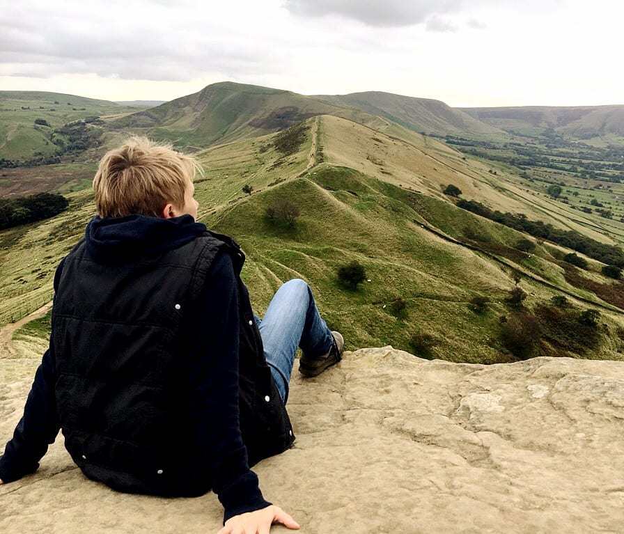
Beautiful Eyam Walk: Introduction
This wonderful Eyam walk gives you two beautiful Peak District villages for the price of one – what more could you want?! The route is a Figure of 8, with historic Eyam providing the start, middle and end point. You could do both circles with a break in the middle or choose to complete either one on its own.
The first half of this Eyam walk of the Figure of 8 takes you out of Eyam, past the Riley Graves and down to the pretty village of Stoney Middleton, with fantastic views along the way.
The second half takes you through Eyam and out in the other direction, offering splendid views over the village from Eyam Edge before returning to your start point.
This is a circular Eyam walk of just over 5 miles. For the most part it uses clearly-marked trails and grassy paths, with some country lanes. Be aware that there is a short section along a (quiet) road with no footpath. The route is undulating but has a few steep uphill sections. There are a few stiles and some gates. Parking is free in the village and there are tea rooms, cafes and pubs in Eyam for refreshments. There are public toilets at the halfway point. Allow 3-4 hours to complete this walk at a moderate pace, allowing for rest stops to take in the views, or more if you want to visit the historic sites in Eyam en route.
Note: This Eyam walk is provided in good faith and is correct at the time of publication. Please be aware that routes may be diverted over time as paths and access are altered, particularly in farming areas. Our directions should not be used instead of a map. You should always take a map with you to cross-reference the route.
Beautiful Eyam Walk : The Plague Village of Eyam
Eyam is a fascinating village to explore. It is perhaps best known for being the site of an outbreak of the bubonic plague in the 1600s. In 1665 a local tailor took delivery of a bundle of cloth from London which turned out to be infested with fleas. Within only a few days the tailor’s assistant had died, and others in the household were very sick. As more residents died over the following weeks, the community’s rector, Rev William Mompesson, persuaded the villagers to quarantine themselves to prevent the spread of disease to neighbouring areas.
Nobody left or entered Eyam for the next 14 months, during which time at least 270 of the 350 villagers died of the plague. Supplies were brought in to the village and left on a boundary stone, with the money to pay for them left on the same stone in exchange. The Boundary Stone is still standing to this day and can be seen on a short detour from this walk. This huge act of sacrifice by the people of Eyam meant that the plague was contained and did not spread to neighbouring villages, saving hundreds or possibly even thousands more lives.
Beautiful Eyam Walk : Directions
1. Park in the centre of the village, close to either the Village Green Café or Eyam Tea Rooms. There is usually plenty of free street parking, but please park considerately. Walk out of the village in an easterly direction, turning to your left if you have the Village Green Café behind you, or to your right if you have Eyam Tea Rooms behind you. Note the plaques on various buildings as you walk past, denoting buildings of significance in the history of the plague in Eyam. Where the road splits, take the left path to follow Riley Lane.
2. Continue following Riley Lane as it winds up a gentle hill through trees, ignoring a private track off to a farm on the left. After a short distance you will see the Riley Graves surrounded by a stone wall in a field on your left. These graves mark the burial spots of a family of six children and their father, all of whom died within the same week.
 1")
3. Continue following the track, with fabulous views over the Derwent Valley to your right. Look out for a Byway sign off to your right soon after the path has curved left, and follow the byway through a beautiful section of woodland. Continue straight on the main path, ignoring footpaths off.
 2")
4. Where the path emerges on to a quiet road, turn right, again with fabulous views ahead of you. As the road curves right look out for a Byway sign by a gate, and follow the byway down to the left of the road. Be aware that the terrain is uneven in places.
 3")
5. This pretty track passes through lovely beech woodland and down, past a cemetery on the left, into the village of Stoney Middleton. Follow the track as it becomes a road into the village. You will pass the spectacular church of St Martin’s on your left. With a beautiful octagonal shape and dating from the 15th Century, it is well worth a visit. The ‘Roman Bath House’ on the right is actually much more modern, being a public bathing house from the 19th Century.
 4")
6. When you reach a T-junction, take the right hand road leading up and away from the main road. After approx. 200 metres, take a no-through-road on your right hand side, with an obvious chapel building visible ahead of you. Almost immediately the road splits again, and you should follow the left hand path signed Cliff Bottom, rather than the public footpath on The Fold. This pretty path takes you over a stile beside a gate, and up through fields that lead back to Eyam.
7. If you wish to take a short diversion to see the Boundary Stone, look out for a lane on the left past farm buildings as you approach the village. Follow this lane for approx. 500 metres through fields to find the Boundary Stone ahead of you.
8. To continue on the walk, continue on the path as it bears right and returns you to the village of Eyam. You will pass the Lydgate Graves on your left, the burial spots of two villagers. Walk back down into the village and the starting point of your route. If you’re looking for refreshment at this stage, try the fabulous Miner’s Arms pub in the centre of the village, offering great food and local ales.
 5")
9. To continue on the second half of the Figure of 8, turn left as you approach the village centre and follow Church Street. This takes you past the village school and the church of St Lawrence on your right, which is well worth a visit. The church dates from the 14th Century and houses a very interesting display about the history of the village. Look out for poignant plaques through this part of the village giving details about the inhabitants of the buildings during the time of the Plague.
10. Follow this road a little further and you will pass Eyam Hall on your right. This beautiful Jacobean Hall dates from 1672 and has been owned and managed by the same family for more than eleven generations. It is open to the public on certain days, see www.eyamhall.net for information. Its stable yard houses a number of local craft shops and restaurants. Opposite Eyam Hall you will find the old village stocks and a small but interesting Visitor Information Centre.
 6")
11. Continue the walk along Church Street, following the road as it bears left. Immediately after the little general store on the right, turn right on to Hawkhill Road, following signs to the Museum. The Museum is small but packed with interesting information about the history of the village and is well worth spending some time visiting. There are public toilets here too.
 7")
12. Continue along Hawkhill Road with the Museum on your left, rising up and out of the village. As the footpath ends and the road bends right, take the road on your left called The Nook. This road soon peters out to a dirt track that winds up quite steeply through trees, offering fabulous views of Eyam village and the surrounding landscape as it climbs. Ignore all public footpaths off and continue on the main path uphill until you reach a junction with a road, Sir William Hill Road.
13. If you wish to make a detour here to see Mompesson’s Well, which was another key boundary marker during the time of the Plague in Eyam, turn right on Sir William Hill Road and follow it carefully (there is no footpath) for approx. 300 metres until you reach another road. Turn left and Mompesson’s Well is almost immediately on the left hand side. Retrace your steps after your visit to continue the walk.
14. To continue the walk, turn left on Sir William Hill Road, looking out for the fine views on the left hand side over Eyam and beyond. After approx. 250 metres look out for a public footpath on the left that crosses a stile through a field and then over another stile. After the second stile, turn left and then almost immediately right, following a beautiful path down through woodland, again with lovely views to the left.
 8")
15. Follow the obvious path straight on down through the beech wood, over a field and through another stretch of woodland. In this second patch of woodland look out for a characterful ruined barn with an abandoned millstone lying close by.
 9")
16. Emerge from the woodland through a gate and head straight on across the field in front of you, keeping slightly to the left of two trees in the centre of the field. Cross over a stile and through another gate, always keeping straight on, in to the yard of a rather unattractive small minerals processing plant. Turn left just beyond the door marked Supervisor’s Office on to the access road for the plant, soon emerging on to the main road again. Turn left on the (quiet) road and continue back down into the village of Eyam. Be aware that the road here has no footpath for a short stretch.
17. As before, look out for plaques as you enter Eyam that tell the story of some of the buildings in the times of the Plague. Follow this road as it winds back into the village, passing Eyam Hall and the church again, this time on your left, and return to your starting point.
Love this walk? Here are a few more you might enjoy…
Try the reverse direction Stoney Middleton via Coombs Dale (4.75 miles), or head to the water on the popular Ladybower Reservoir Walk (5.5 miles). For a train‑station ramble, see Hathersage Walk via Grindleford (6 miles), and check the Hope Valley Train Station Walks for car‑free ideas. Still looking? Explore all our Peak District walks.
)